
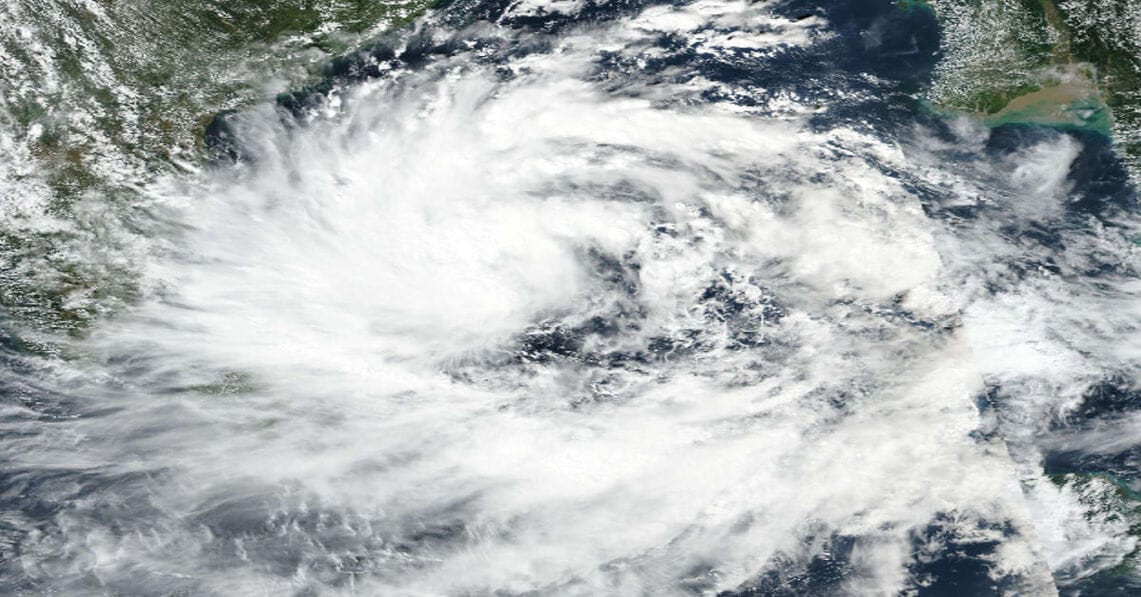
A fresh cyclonic threat is forming over the Bay of Bengal — the weather system named Cyclone Montha is expected to intensify rapidly and impact India’s east coast. The India Meteorological Department (IMD) and state authorities have issued multiple alerts for coastal areas of Andhra Pradesh, Tamil Nadu and Odisha as heavy rain, strong winds and rough seas loom ahead.
1. What is Montha and how did it come about?
Montha began as a low-pressure area over the southeast Bay of Bengal, which the IMD monitored for signs of strengthening. According to the bulletin, it was likely to intensify into a deep depression by October 26 and achieve cyclonic-storm status by October 27.
Table of Contents
Once the system reaches the required wind and structural thresholds in the north Indian Ocean region, it receives a name from the predetermined list used by the WMO/ESCAP panel. In this case, the name “Montha” was contributed by Thailand and means “fragrant flower” or “beautiful flower” in Thai.
2. Forecast & trajectory
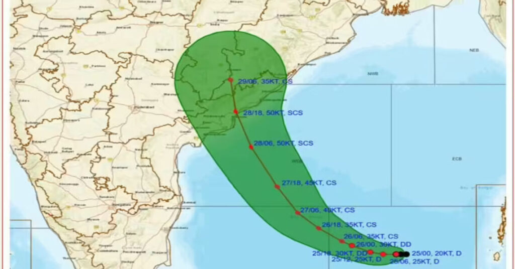
- The system is moving west-north-westwards over the southwest and adjoining west-central Bay of Bengal.
- IMD predicts that Cyclone Montha will escalate into a severe cyclonic storm by around the morning of October 28.
- Landfall is expected between Machilipatnam and Kalingapatnam, near Kakinada in Andhra Pradesh, during the evening or night of October 28.
- Forecast wind speeds at landfall: sustained winds of 90-100 km/h, gusting up to 110 km/h
- Heavy to very heavy rainfall is expected over large parts of coastal Andhra Pradesh during 27-29 October, Odisha on 28-29 October, and spillover into other states including Tamil Nadu, Telangana and Chhattisgarh.
3. Areas at risk & alert status
- Coastal districts of Andhra Pradesh (including Kakinada, Konaseema, West Godavari, Krishna, Bapatla, Prakasam, Nellore) are under red/orange alerts for heavy rain and gusty winds.
- In Odisha, seven districts (Koraput, Malkangiri, Rayagada, Nabarangpur, Kalahandi, Ganjam, Gajapati) have been issued a red warning.
- Tamil Nadu’s northern and coastal districts (including Chennai) are forewarned of heavy to very heavy rain and gusty winds.
- Fisherfolk have been advised not to venture into the sea along the Bay of Bengal, especially off the Andhra-Odisha coasts, until further notice.
4. Expected impacts
Rainfall & flooding:
Heavy to very heavy rainfall could trigger flash floods, waterlogging of low-lying areas, and river/stream swellings. In hilly terrain, landslides are a possibility.
Wind damage & sea conditions:
Gusty winds reaching up to 110 km/h may uproot trees, damage weak structures, cause power outage, and disrupt communication. Rough sea conditions, high waves and storm surge could affect coastal communities.
Agriculture, infrastructure, way of life:
Coastal agricultural areas, especially paddy fields, may suffer waterlogging or crop damage. Transport services (rail, road) may be disrupted; relief shelters and evacuation may be needed for vulnerable populations.
5. Preparations & advisories
- Governments of Andhra Pradesh and Odisha have cancelled leaves for emergency staff, readied shelters, stockpiled essential supplies, and moved out thousands of people from vulnerable areas.
Schools and colleges in the affected districts have been shut or converted into relief camps.
Coastal residents are advised to stay indoors, avoid moving about during the storm, secure loose objects and boats, and follow instructions of disaster management authorities.
Avoid going to sea, keep away from beaches, river mouths and embankments; maintain communication and heed weather bulletins.
6. Why this matters
The east coast of India is prone to cyclonic storms during the retreating monsoon and pre-winter seasons. Even a moderate storm can lead to serious impacts because of the dense population, low-lying terrain and coastal infrastructure. With Cyclone Montha expected to intensify and make landfall near a densely inhabited region, the risk to lives, livelihoods, infrastructure and agriculture is substantial.
READ ALSO- I Will Die”: Indian Man Stranded in Saudi Desert with Camel Pleads to PM for HelpThe naming and tracking of storms like Montha helps in early warning dissemination, enabling timely evacuations and preparations. The name itself — “fragrant flower” — belies the fierce power such systems can display.
7. What to watch for (next 24-48 hours)
- Monitor official bulletins from the IMD and state disaster management authorities for updated maximum wind speed, central pressure and exact landfall timing.
- Stay alert to shifting forecasts of track: slight deviations can change which districts face the worst impact.
- Prepare for heavy rainfall and possible inland impacts even after landfall, as the system may weaken slowly, spreading rain to neighbouring regions.
- After the storm passes, expect power cuts, water supply disruption and damage along the coast — authorities will issue post-storm safety advice.
Cyclone Montha is taking shape as a significant weather event for India’s east coast. While forecasting gives a window for preparation, the inherent uncertainty of cyclonic behaviour means constant vigilance is needed. For residents in coastal Andhra Pradesh, Odisha and Tamil Nadu — and for those whose livelihoods or homes lie in the storm’s path — the coming days are crucial. Heed official warnings, ready for evacuation if required, and stay safe while the ocean unleashes its power.